Urgent Alert: Tornado Watch Issued for Houston & Southeast Texas Tonight
As evening descends upon Houston and much of Southeast Texas, residents are urged to remain vigilant and prepared. The National Weather Service has issued a Tornado Watch for Houston and surrounding areas, effective until 9 p.m. Saturday night. This watch encompasses a broad region, including the bustling Houston metro area, Galveston, Beaumont, The Woodlands, Conroe, Huntsville, Livingston, Lufkin, Nacogdoches, Tyler, and Port Arthur.
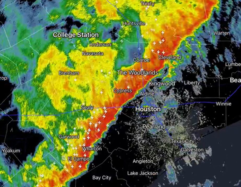
A dynamic line of strong to severe thunderstorms, which has already pushed east of College Station and San Antonio, is making its way across the region. These storms are moving into an environment with moderate atmospheric instability, providing the fuel needed for them to strengthen as they advance eastward. While a widespread tornado outbreak is not anticipated, the primary threats include potent straight-line winds and the possibility of embedded, short-lived tornadoes within the storm complex.
Your safety is paramount. Understanding the specific threats and knowing how to react instantly can make all the difference. This article will break down what to expect tonight, delve into the science of these powerful storms, and provide actionable advice to ensure you and your loved ones stay safe.
Understanding the Threat: What to Expect from Tonight's Storms
The approaching line of thunderstorms poses several serious hazards to the Houston area tonight. Based on current models and expert analysis, the storm's impact will be phased across the metroplex:
- Western suburbs: Expect impact around 6 p.m.
- Downtown corridor: Closer to 7 p.m.
- Eastern suburbs and Galveston: Just before 8 p.m.
It's important to note that these timings are estimates; storm systems, particularly those fueled by a cold pool, can sometimes move slightly faster than predicted. Therefore, continuous monitoring of local weather reports is essential.
Primary Dangers: Winds, Hail, and Hidden Tornadoes
While the term "tornado watch" understandably raises alarm, it's crucial to understand the specific nature of tonight's threats:
- Straight-Line Winds: These storms are capable of producing wind gusts up to 60-70 mph. Often underestimated, straight-line winds can cause damage comparable to a weak tornado, tearing off shingles, knocking down trees, and turning loose objects into dangerous projectiles. This makes staying indoors, away from windows, a critical safety measure.
- Quarter-Sized Hail: Some storms within the line may also produce hail roughly the size of a quarter. While not as immediately destructive as high winds or tornadoes, hail can damage vehicles and property, and pose a risk to anyone caught outside.
- Embedded, Rain-Wrapped Tornadoes: This is arguably the most insidious threat of tonight's system. Unlike the classic funnel cloud visible against a clear sky, these tornadoes form within the primary line of storms and are often obscured by heavy rain. This makes them incredibly difficult to spot, even in daylight, and virtually impossible to see after dark. Because they are hidden, there is little to no visual warning, demanding a heightened state of readiness if a tornado warning is issued for your area. These types of tornadoes rarely reach EF2 strength or higher, but any tornado, regardless of its rating, carries the potential for significant danger and destruction. For a deeper dive into these specific storm phenomena, consider reading Understanding Houston Storms: Rain-Wrapped Tornadoes & Wind Threats.
Given the characteristics of these embedded tornadoes, it's vital to heed all official warnings immediately. Do not wait for visual confirmation. If you are in an area under a tornado warning, seek shelter without delay.
The Science Behind the Fury: How Tornadoes Form in Supercell Thunderstorms
To truly appreciate the power of a Tornado Houston residents might face, it's helpful to understand the meteorological forces at play. Tornadoes are among the most violent natural phenomena, characterized by rapidly rotating columns of air that extend from a thunderstorm cloud to the earth's surface. While tonight's specific threat involves smaller, embedded tornadoes, the underlying principles of their formation are rooted in the dynamics of supercell thunderstorms.
The most powerful and persistent tornadoes are typically spawned by supercell thunderstorms. These aren't your average rain showers; they are highly organized, long-lived storms with a deep, rotating updraft known as a mesocyclone. The process begins when:
- Horizontal Wind Shears: Varying wind speeds and directions at different altitudes create a "horizontal tube" of rotating air within the atmosphere.
- Updrafts Tilt Rotation: Powerful updrafts within the thunderstorm ingest this horizontally rotating air. As the air rises, the updraft tilts this rotation vertically, stretching and intensifying it.
- Mesocyclone Formation: This vertical rotation becomes a mesocyclone, the heart of a supercell. As the mesocyclone strengthens and lowers, a rapidly swirling column of air can extend down to the ground, giving birth to a tornado.
Even though tonight's storms are not expected to produce a widespread outbreak of EF2+ tornadoes, the atmospheric instability mentioned by the National Weather Service provides sufficient energy for storms to strengthen and for those critical interactions between wind shear and updrafts to occur, leading to the formation of localized, short-lived tornadoes. This scientific backdrop underscores why vigilance is crucial even when a "widespread outbreak" isn't predicted.
Your Action Plan: Essential Steps to Stay Safe During a Tornado Watch
During a Tornado Watch for Houston, preparation is your best defense. This period means conditions are favorable for tornadoes to develop, so it's time to review and implement your safety plan. Here's what you need to do:
Before the Storm Arrives (Tornado Watch):
- Stay Informed: This is paramount. Listen to official weather reports from the National Weather Service (NWS), local news, or trusted weather apps. Register for emergency alerts from Houston OEM or your local emergency management agency. These alerts often provide crucial, real-time updates directly to your phone.
- Know the Signs of a Tornado: While rain-wrapped tornadoes make visual identification difficult, other atmospheric cues can signal danger. These include a dark, often greenish sky, a wall cloud (a lowered portion of the storm base), a loud roar similar to a freight train, and flying debris.
- Identify and Practice Your Safe Spot: Every home should have a designated safe place. This should be a small, interior, windowless room on the lowest level of your home, such as a bathroom, closet, or an interior hallway. Basements offer the best protection. The goal is to put as many walls between you and the outside as possible to protect against flying debris and potential structural collapse. Practice getting to this location quickly with all household members, including pets. For more comprehensive guidance on preparing your safe spot, refer to Houston Tornado Safety: Essential Prep & Identifying Your Safe Spot.
- Prepare an Emergency Kit: Have a grab-and-go kit ready. This should include essentials like a flashlight with extra batteries, a battery-powered or hand-crank radio, a first-aid kit, water, non-perishable food, copies of important documents, and any necessary medications. Don't forget chargers for your mobile devices.
- Secure Outdoor Items: Bring in or tie down anything outdoors that could become a projectile in high winds, such as patio furniture, trash cans, and toys.
During the Storm (Tornado Warning Issued):
A tornado warning means a tornado has been sighted or indicated by radar. This requires immediate action:
- Go to Your Safe Spot Immediately: Do not wait for visual confirmation, especially with the threat of rain-wrapped tornadoes. Every second counts.
- Protect Your Head and Neck: Once in your safe spot, crouch down and cover your head and neck with your arms. Use a sturdy object like a table, mattress, or even a bike helmet for added protection.
- Stay Away from Windows: Even in your safe room, ensure you are away from any exterior walls or windows, which are vulnerable to breakage.
- Bring Pets with You: Have a plan to get your pets to your safe location quickly. They are part of the family and need protection too.
- If Outdoors: Seek sturdy shelter immediately. If no shelter is available, lie flat in a ditch or other low-lying area and cover your head with your arms.
After the Storm:
- Stay Tuned: Continue to monitor official sources for updated information or further warnings.
- Assess Damage Safely: Once the immediate threat has passed, carefully check for damage. Be wary of downed power lines and gas leaks.
- Check on Neighbors: If it's safe to do so, check on elderly or vulnerable neighbors.
Beyond Tonight: Staying Prepared for Houston's Dynamic Weather
Tonight's Tornado Watch for Houston serves as a critical reminder of the unpredictable and sometimes severe weather that can impact our region. While this specific event is expected to conclude by 9 p.m., the lessons learned from preparing for it should extend far beyond this evening. Houston's unique geographical position and climate make it susceptible to a variety of powerful storms, from tropical systems to severe thunderstorms capable of producing hail, destructive winds, and tornadoes.
Ongoing vigilance and proactive preparedness are key to ensuring the safety and resilience of our communities. Make weather awareness a habit, regularly review and update your family's emergency plan, and ensure your safe spot is always ready. By understanding the threats, staying informed through official channels, and knowing exactly what to do when a warning is issued, you empower yourself and your loved ones to face whatever Mother Nature brings. Stay safe, Houston, and remember that preparedness is a continuous journey, not a one-time event.